Hiking report from Lappland 1999
For some inexplicable reason I left the warmest summer anyone could remember
in southern Sweden for a 3 day hike in Lappland, where they were having the worst
summer for years. I even went up a few days early and spent a day paddling
on Torneträsk in 4°C wind and rain just to make sure that I was fighting off
a cold when I arrived at Vassijaure railway station with Al, my exotic Tasmanian
partner for the trip. We had hoped to take the regular tourist route route
leading up from Låktatjåkka railway station, but having discovered rather
late that the train doesn't stop there anymore, we opted to go up the parallel
Kärkevagge instead, rather than hiking an hour back up the railway line.
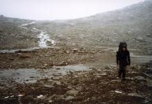
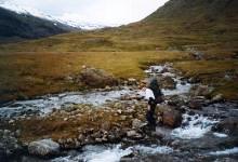 The first couple of hours were pleasant enough, 10°C, sunny, and a fresh breeze
from the south west as we gently ascended 300m over 5km on well-travelled
paths through the
blueberry bushes and dwarf birches, which being late August were just starting to think about changing colour.
The first couple of hours were pleasant enough, 10°C, sunny, and a fresh breeze
from the south west as we gently ascended 300m over 5km on well-travelled
paths through the
blueberry bushes and dwarf birches, which being late August were just starting to think about changing colour.
In the bottom of the valley we could see the standing stones that draw people on day trips,
but we were headed up to Troll Lake that sits in the imposing cirque at the top of the valley.
As we approached it we could see white-topped waves on its surface, which was surprising
considering how sheltered it is from all but the north west. When we arrived my
windmeter pegged out at its maximum reading of 30 m/s (60mph), so we could
only imagine what it was blowing 600m up the protective wall.
The only way to find out was to find a climable route up the irregular slope.
The first vertical 200m averaged 45°, and I was struggling badly until
I handed over 5kg of food to Al, so that he now had 25kg and I had 15kg,
which still didn't cancel his advantage of 15 years less bodily decay,
and having mountain goats for parents, but at least we both got up to the
1200m mark, where the slope lessened, but 10cm of soft new snow made it hard to
walk on the invisible irregularities of the scree underneath.
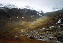
After chasing many false summits we found ourselves 40m under Kärketjårro (1388m),
but had no urge to bag the peak because of the awful wind that was now carrying
4-degree rain with it. But we did have a beautiful view across the valley, to
where the Låktatjåkka mountain station sat majestically in the pass 4km away.
We decided to try to camp by one of the lakes in Kuoblavagge where it might be more
sheltered, and headed off between peaks 1419 and 1391, squeezing around the lake below them. Conditions were much harsher than on most of the winter trips
I've been on, and I was glad that I had brought pretty much the same equipment
as I take on those. The biggest difference is that one doesn't get wet in the winter,
and the rain was chilling me much faster than a -20°C snowstorm.
The lake was the first water source we had seen for several hours, and we swallowed
as much of the icy liquid as we could bear. This revived me greatly, and made me realise
how dehydrated I had become. I felt so good that I almost shared Al's enthusiasm
for what great fun we were having.
 The appearance of our destination was a great disappointment - far from
the verdant, comforting home we had hoped for, Kuoblavagge was a dark, hostile-looking
mixture of sharp granite boulders and mud flats 150m below us.
We couldn't camp where we were because the snow covering the scree wouldn't support our tent.
We had already ascended about 800m and covered about 14km over difficult ground,the rain was turning to snow,
and we didn't want to go much further, so Al made the odd suggestion that we camp on the glacier we stood beside,
to which I agreed whole-heartedly. The snow was firmer and deeper, and would be cooled
by the ice, so that it wouldn't melt so much from our body heat.
The biggest problem was building a flat base on the sloping surface, since
for some reason one item of equipment that I had failed to pack
for my summer holiday was a snow shovel, but with hands and feet we did a pretty
good job and were soon safely in
our new home. Well, safe until more rain
started to melt the snow packed around our tent pegs, and the storm-force winds
flattened the fly against the tent as they pulled out one by one.
We had to run out and do some engineering with big rocks and pieces of string
to avoid the inner tent suffering the same fate.
The appearance of our destination was a great disappointment - far from
the verdant, comforting home we had hoped for, Kuoblavagge was a dark, hostile-looking
mixture of sharp granite boulders and mud flats 150m below us.
We couldn't camp where we were because the snow covering the scree wouldn't support our tent.
We had already ascended about 800m and covered about 14km over difficult ground,the rain was turning to snow,
and we didn't want to go much further, so Al made the odd suggestion that we camp on the glacier we stood beside,
to which I agreed whole-heartedly. The snow was firmer and deeper, and would be cooled
by the ice, so that it wouldn't melt so much from our body heat.
The biggest problem was building a flat base on the sloping surface, since
for some reason one item of equipment that I had failed to pack
for my summer holiday was a snow shovel, but with hands and feet we did a pretty
good job and were soon safely in
our new home. Well, safe until more rain
started to melt the snow packed around our tent pegs, and the storm-force winds
flattened the fly against the tent as they pulled out one by one.
We had to run out and do some engineering with big rocks and pieces of string
to avoid the inner tent suffering the same fate.
 We declared an emergency to allow ourselves to use the
instant freeze-dried dinners
that I had hidden away for times like this, but even preparing those involved
the loss of our frying pan, which was doing service as a lid on the water pot.
It was caught by a gust of wind and made an extraordinary sprint for freedom,
accelerating across the glacier in a flat spin just above the surface,
until our Unidentified Frying Object slipped off the edge of our frozen universe 100m away.
We declared an emergency to allow ourselves to use the
instant freeze-dried dinners
that I had hidden away for times like this, but even preparing those involved
the loss of our frying pan, which was doing service as a lid on the water pot.
It was caught by a gust of wind and made an extraordinary sprint for freedom,
accelerating across the glacier in a flat spin just above the surface,
until our Unidentified Frying Object slipped off the edge of our frozen universe 100m away.
 The wind seemed to get worse during the night, and between the noise,
being woken by Al telling me that he thought the tent was going to blow away,
and the interestingly-contoured
ice sheets that were now our beds, it was not one of the most restful nights I've had.
The aluminium packets from our dinners were assigned as wee-bags,
since we had no intention of heading out and exposing body parts to this weather.
The wind seemed to get worse during the night, and between the noise,
being woken by Al telling me that he thought the tent was going to blow away,
and the interestingly-contoured
ice sheets that were now our beds, it was not one of the most restful nights I've had.
The aluminium packets from our dinners were assigned as wee-bags,
since we had no intention of heading out and exposing body parts to this weather.
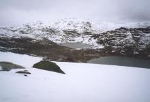
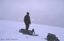
 By morning the rain had turned to snow, and it was hard work digging the tent
out from under the layer of sleet that was crushing the windward side.
It was still snowing at 10-15 m/s as we hiked along the top of the glacier,
careful not to stray on to the body where crevasses might lurk.
Still, Al managed to drop into a meter-deep hole, which when we peered into it,
seemed to have pieces of wood on its sides.
By the time we had reached the lakes 150m below,
the snow was turning to
rain again, and vegetation reappeared as we progressed down the valley.
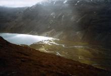
At the junction with Kårsavagge we even had some sun to illuminate
the spectacular view
west to the snow-capped Piran, and
east down the valley
to the lake of Kårsavaggejaure. The next steep, 600m descent was tough
with my full 20kg pack again, and I was very happy when the 90-year-old
cabin came into sight. It is one of the few cabins that has survived so long,
and has a wonderful woody atmosphere.
By morning the rain had turned to snow, and it was hard work digging the tent
out from under the layer of sleet that was crushing the windward side.
It was still snowing at 10-15 m/s as we hiked along the top of the glacier,
careful not to stray on to the body where crevasses might lurk.
Still, Al managed to drop into a meter-deep hole, which when we peered into it,
seemed to have pieces of wood on its sides.
By the time we had reached the lakes 150m below,
the snow was turning to
rain again, and vegetation reappeared as we progressed down the valley.
At the junction with Kårsavagge we even had some sun to illuminate
the spectacular view
west to the snow-capped Piran, and
east down the valley
to the lake of Kårsavaggejaure. The next steep, 600m descent was tough
with my full 20kg pack again, and I was very happy when the 90-year-old
cabin came into sight. It is one of the few cabins that has survived so long,
and has a wonderful woody atmosphere.
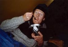
 Al was restless and took a 3-hour stroll up a hill while I pottered around,
drank tea, and chatted to the adorable Pia, the friendliest and coolest warden
I've ever met. In the evening, alone in the cabin, Al and I cranked up the stove
to dry out our equipment, and set off next morning refreshed and dry,
in the most perfect weather - no wind, 10°C and sunny.
Pia joined us for the first couple of hour's hike 600m up on to Kårsavagge, and taught us to
kula, a sort of Scandinavian yodle, before she veered off to see if the guys at
the research station had any plans to fire up the sauna that evening.
My guess is that they said yes.
Al was restless and took a 3-hour stroll up a hill while I pottered around,
drank tea, and chatted to the adorable Pia, the friendliest and coolest warden
I've ever met. In the evening, alone in the cabin, Al and I cranked up the stove
to dry out our equipment, and set off next morning refreshed and dry,
in the most perfect weather - no wind, 10°C and sunny.
Pia joined us for the first couple of hour's hike 600m up on to Kårsavagge, and taught us to
kula, a sort of Scandinavian yodle, before she veered off to see if the guys at
the research station had any plans to fire up the sauna that evening.
My guess is that they said yes.
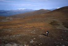 Then the hardships of the trip started to pay off, as we hiked along the
lofty, easy terrain with fantastic views of the surrounding peaks,
wearing only our undershirts.
It was interesting to note that moving just 6 or 7 km east into the rain shadow
of Abisko National Park, the snow level had moved up several hundred meters.
We didn't rush, and it was 7pm before we came out at the top of Abisko's ski
slope on Njulla, with its view along Torneträsk and over to Lapporten.
We almost camped there under the setting sun, but the lure of beer and sauna sent us
trotting down to the tourist station below.
Then the hardships of the trip started to pay off, as we hiked along the
lofty, easy terrain with fantastic views of the surrounding peaks,
wearing only our undershirts.
It was interesting to note that moving just 6 or 7 km east into the rain shadow
of Abisko National Park, the snow level had moved up several hundred meters.
We didn't rush, and it was 7pm before we came out at the top of Abisko's ski
slope on Njulla, with its view along Torneträsk and over to Lapporten.
We almost camped there under the setting sun, but the lure of beer and sauna sent us
trotting down to the tourist station below.
All in all it was a fun trip, but would have been a lot more enjoyable with
better weather. We heard later that at Tarfala research station they had
registered hurricane-force winds the night we were camping, and that Pia had
been seriously considering leaving her warden's cabin in case it blew over.
Full marks at least for Hilleberg's tent construction.
Postscript :
Remember the house that Al fell off ? Well, a few weeks later I got
a phone call from an excited glacial archeologist who had heard the story
and was sending up a helicopter with researchers to find what he thought could
be an important piece of history that had popped up because the glaciers
had shrunk back unusually much this year. Kicking myself for not realising its significance
and neither photographing it nor noting its position, I gave him all the information I could.
What I remember seeing when Al dropped into the ground that day is this :
The hole was one or two hundred meters south of our camp site (at SG E1607596 N7589776)
about one meter deep and half a meter across, elongated deeper down
perpendicular to our southerly path. Along the back (northern) wall were visible
a few decimeters of what looked like planed wooden beams stacked upon each other
to make a wall. The highest visible section was less than half a meter from the snow surface,
which immediately made me wonder where the roof could be, if this were indeed a
building. I also wondered why the sink hole that we were looking into hadn't
ever filled up with snow, and indeed why there would be any construction up here.
We joked at the time that we should have tried to dig our way down to a door
instead of spending the night in our tent, and then carried on, thinking that
buried buildings were maybe something that you find all the time in Lappland,
or that it was just a small bunker. We later asked Pia what it might be,
which is how Christer Jonasson, the glaciologist and director of the Abisko
Scientific Research Station got to hear about it.
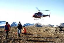
 But his team found nothing, so the next day I found myself unexpectedly whizzing
back up to Abisko, and then being
helicoptered
up to the glacier in 10 minutes
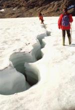
(compared to maybe 6 hours hiking). We quickly found the site where we had camped,
but with all the snow gone it was hard to identify the straight line we had
taken to be the top of the glacier when we hiked in the snowstorm - in fact
the glacier has a top lip bulging out into what we believed to be a fresh snow field,
so we had probably hiked right across the body, which we now saw to be littered
with
crevasses up to four meters deep. These were not tension-induced crevasses,
but eroded by water, and so they meandered, explaining why only a few decimeters
of timber were visible, if the outside edge of the meandering had just reached the structure. When I saw the first of these crevasses I was very excited, as until
that point I thought we would be probing through loose snow to find a sink hole,
but now it seemed more likely that Al had fallen into one of these crevasses and
just punched a round hole in the fresh snow roof. But sadly, after 3 hours
of hiking around and peering into every crack we saw, nothing resembling
our timber wall appeared. My worst fear was that we would find a rock wall
that was striated to look like timbers, but we didn't even find flat rock in the
right orientation or position. With a month of warm, dry weather since our
discovery, it's hard to believe that the wall had become less exposed rather than more
(though if it were a sink hole, it could have filled with fresh snow after we left),
so the most likely explanation is that extra-terrestrials are moving their
settlements from under the polar ice-cap towards warmer climes,
and that their activities are being covered up by covert government forces.
Or possibly that we weren't looking in quite the right place on the glacier.
But his team found nothing, so the next day I found myself unexpectedly whizzing
back up to Abisko, and then being
helicoptered
up to the glacier in 10 minutes
(compared to maybe 6 hours hiking). We quickly found the site where we had camped,
but with all the snow gone it was hard to identify the straight line we had
taken to be the top of the glacier when we hiked in the snowstorm - in fact
the glacier has a top lip bulging out into what we believed to be a fresh snow field,
so we had probably hiked right across the body, which we now saw to be littered
with
crevasses up to four meters deep. These were not tension-induced crevasses,
but eroded by water, and so they meandered, explaining why only a few decimeters
of timber were visible, if the outside edge of the meandering had just reached the structure. When I saw the first of these crevasses I was very excited, as until
that point I thought we would be probing through loose snow to find a sink hole,
but now it seemed more likely that Al had fallen into one of these crevasses and
just punched a round hole in the fresh snow roof. But sadly, after 3 hours
of hiking around and peering into every crack we saw, nothing resembling
our timber wall appeared. My worst fear was that we would find a rock wall
that was striated to look like timbers, but we didn't even find flat rock in the
right orientation or position. With a month of warm, dry weather since our
discovery, it's hard to believe that the wall had become less exposed rather than more
(though if it were a sink hole, it could have filled with fresh snow after we left),
so the most likely explanation is that extra-terrestrials are moving their
settlements from under the polar ice-cap towards warmer climes,
and that their activities are being covered up by covert government forces.
Or possibly that we weren't looking in quite the right place on the glacier.
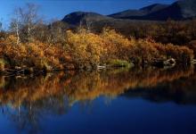
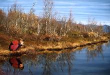 I enjoyed my extra trip anyway, seeing
the post-autumn colours,
the rivers, and
the lakes,
and luxuriating in the wonderful wood-fired sauna by the lake that
was a refreshing 5°C that evening.
I enjoyed my extra trip anyway, seeing
the post-autumn colours,
the rivers, and
the lakes,
and luxuriating in the wonderful wood-fired sauna by the lake that
was a refreshing 5°C that evening.
But the mystery remains, and if you find yourself up on Kuobla glacier during the summer,
keep your eyes open for a timber construction peeping out of the ice, and you could
make a lot of people very happy, and I for one will buy you a crate of beer.
© Mark Harris 1999
(To ski report index)
(MRH homepage)

 The first couple of hours were pleasant enough, 10°C, sunny, and a fresh breeze
from the south west as we gently ascended 300m over 5km on well-travelled
paths through the
blueberry bushes and dwarf birches, which being late August were just starting to think about changing colour.
The first couple of hours were pleasant enough, 10°C, sunny, and a fresh breeze
from the south west as we gently ascended 300m over 5km on well-travelled
paths through the
blueberry bushes and dwarf birches, which being late August were just starting to think about changing colour.


